The poverty map: Booth’s Deptford, Booth’s Clerkenwell, Booth’s Whitechapel and Booth’s Westminster.
Four walks through Charles Booth’s London
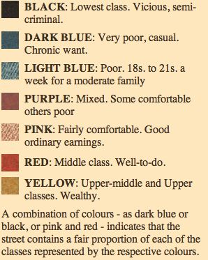 In1902 Victorian reformist Charles Booth published the latest in his series of ‘Poverty Maps’, maps of nearly all of the streets that now exist within zones one and two. Deptford was designated ‘District 45’, Clerkenwell ‘District 5’ and Whitechapel ‘District 7’. The streets were assigned colours according to their socio-economic groupings and these groupings, along with their sometimes dubious descriptions are shown below. In ‘The Life and Labour of the people of London’ (1902) Booth described his aims and methods:
“My first attempt was to enumerate the mass of the people of London in classes according to degrees of poverty or comfort and to indicate the conditions of life in each class. In connection with this attempt I mapped out the streets in colours and endeavoured to show by sample descriptions the kind of persons dwelling therein, their habits and the manner of their lives. My principle aim is confined to the descriptions of things as they are. I have not undertaken to investigate how they came to be so, nor except incidentally to indicate whither they are tending and only to a very limited extent, or very occasionally, has any comparison been made with the past. These points of view are deeply interesting and not to be ignored, but are beyond the scope of my own work.”
Charles Booth quotes and maps courtesy of the London School of Economics